


- Home
- Urban Design and Planning
- Transportation Planning
- Bike Projects
Urban Design and Planning
Bike Projects
The City works on bike projects across the city, including on-street routes and off-street paths. Check out our bike map to see where existing bike lanes and multi-use paths are located around Gresham.
Project information
- Gresham Greenways
- Gresham Trails
- Completed Projects
- Contact
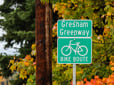
Neighborhood greenways are on low-traffic streets that connect people to parks, schools and business districts. Greenways provide a safer option for people to walk or bike and provide an alternative to bike lanes on high-speed streets. Greenways are part of the City’s Active Transportation Plan, titled Bikes Routes for Everyone.
Greenway projects
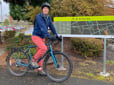
Thanks to Metro funding, the City is installing two new local bike routes, called Gresham Greenways.
The new bike routes connect to parks, downtown businesses, and larger streets and bike paths that are part of the bicycle network. We’d like to know what would help you use the local bike routes more.
West Gresham connector (BR1)
This new route provides a safe route to destinations in Rockwood. View the West Gresham Connector map.
Gresham-Fairview Trail connector (BR9)
This new route connects our existing regional trail system to downtown Gresham. View the Gresham-Fairview Trail connector map.
Multi-use paths
Transportation staff secured two grants worth over $1.3 million through ODOT’s Community Paths Program to develop multi-use paths in North Gresham Park and Columbia View Park. These paths will allow connections of Gresham Greenways through the park, making routes to local destinations more direct.